Garmin eTrex® 30x
Garmin eTrex® Touch 35 Online


Color Touchscreen GPS/GLONASS Handheld with 3-axis Compass, Barometric Altimeter
- 2.6-inch color capacitive touchscreen
- 3-axis tilt-compensated compass and barometric altimeter
- GPS and GLONASS satellites for faster positioning
- 250,000 preloaded geocaches from Geocaching.com
- 4 GB memory to hold more maps
Compact, rugged and reliable GPS/GLONASS handheld with color touchscreen, featuring a barometric altimeter and 3-axis tilt-compensated electronic compass, wireless connectivity, preloaded geocaches and expanded internal memory to hold more maps.
See the Way: eTrex Touch 35 features a sunlight-readable, 2.6-inch color touchscreen display offering intuitive access to worldwide basemap with shaded relief. Durable and water resistant, eTrex Touch 35 is built to keep delivering vital mapping and tracking data no matter what the elements throw at you, standing strong against dust, dirt, humidity and water.
Product description
New Tools for Your Trek
Specs
In The Box
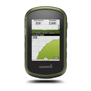
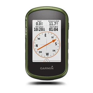
eTrex Touch 35 features a built-in 3-axis tilt-compensated electronic compass that shows your heading even when you’re standing still, and you don’t have to hold it level. Also added is a barometric altimeter, which tracks changes in pressure to pinpoint your precise altitude, and you can even use it to plot barometric pressure over time, which can help you keep an eye on changing weather conditions.
Physical & Performance | |
Physical dimensions | 2.3” x 4.0” x 1.3” (5.8 x 10.2 x 3.3 cm) |
Display size, WxH | 1.43" x 2.15" (3.6 x 5.5 cm) |
Display resolution, WxH | 160 x 240 pixels |
Display type | 2.6" 65K color TFT |
Touchscreen | |
Weight | 5.6 oz (159 g) with batteries |
Battery | 2 AA batteries (not included); NiMH or Lithium recommended |
Battery life | Up to 16 hours |
Water rating | IPX7 |
High-sensitivity receiver | |
Interface | USB |
Barometric altimeter | |
Electronic compass | |
Unit-to-unit transfer (shares data wirelessly with similar units) |
Maps & Memory | |
Basemap | |
Ability to add maps | |
Built-in memory | 4GB |
Accepts data cards | microSD™ card (not included) |
Custom POIs (ability to add additional points of interest) | |
Waypoints/favorites/locations | 4000 |
Routes | 200 |
Track log | 10,000 points, 200 saved tracks |
Outdoor Features | |
Automatic routing (turn by turn routing on roads) | (with optional mapping for detailed roads) |
Geocaching-friendly | (Paperless) |
Custom maps compatible | |
Sun and moon information | |
Tide tables | (with optional Bluechart) |
Area calculation | |
Picture viewer |
Garmin Connect™ | |
Garmin Connect™ compatible (online community where you analyze, categorize and share data) |
Additional | |
Additional | Smart Notifications: yes Live Tracking: yes (with Garmin Connect™ Mobile) |
- eTrex Touch 35
- USB cable
- Documentation
Contact
-
D-67 Defence Colony, GF
New Delhi – 110024, India - (+91-11) 4174 0346/7
- info@gpsindia.net