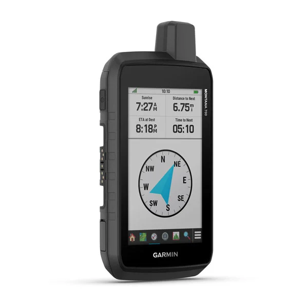
Garmin Montana® 680
EXPLORE YOUR WORLD WITH NAVIGATION YOU TRUST
With routable mapping for roads and trails, the Montana 700 handheld brings advanced outdoor features into a sturdy 5” format that’s ideal for navigation on foot, bike, kayak, ATV and more.


Product description
RUGGED BY DESIGN
This durable, water-resistant handheld is tested to U.S. military standards and features a glove-friendly 5” touchscreen that’s 50% larger than previous Montana models.
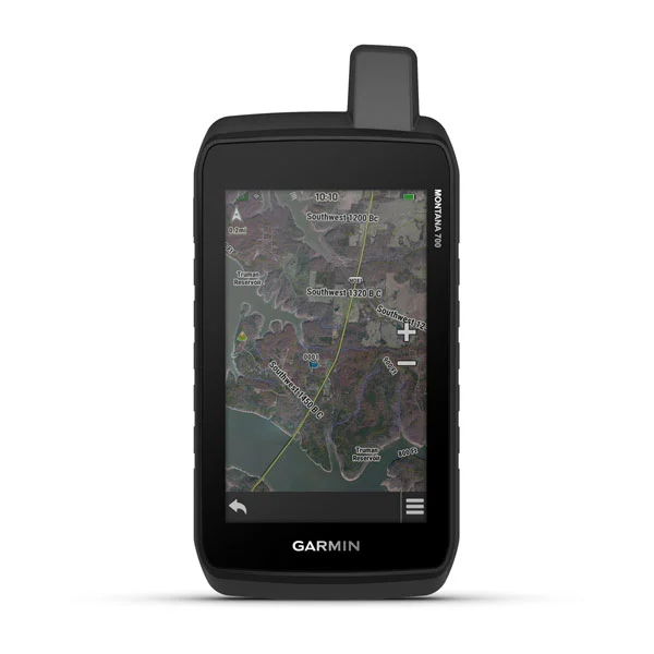
SATELLITE VIEWS
Use direct-to-device downloads of BirdsEye Satellite Imagery (no annual subscription required) to see photo-realistic views and create waypoints based on landmarks.
ADDITIONAL MAPS
With 16 GB of onboard memory and a microSD™ card slot for expandable storage, you can download even more maps such as City Navigator for your drive or BlueChart g3 for the water.
General | |
Physical dimensions | 3.4" x 7.2" x 1.3" (8.76 x 18.30 x 3.27 cm) |
Touchscreen | |
Display size | 2.55"W x 4.25"H (6.48 x 10.80 cm); 5" diag (12.70 cm) |
Display resolution | 480 x 800 pixels |
Display type | WVGA transflective, dual orientation |
Weight | 14.0 oz (397 g) with included lithium-ion battery pack |
Battery type | rechargeable lithium-ion (included) or 3 AA batteries (not included); lithium recommended |
Battery life | GPS Mode: up to 18 hours |
Water rating | IPX7 |
MIL-STD-810 | yes (thermal, shock, water, vibe) |
High-sensitivity receiver | |
Interface | high speed micro USB and NMEA 0183 compatible |
Memory/History | 16 GB (user space varies based on included mapping) |
Maps & Memory | |
Preloaded maps | |
Ability to add maps | |
Basemap | |
Automatic routing (turn by turn routing on roads) for outdoor activities | Yes (with optional mapping for detailed roads) |
Map segments | 15000 |
BirdsEye | yes (direct to device) |
Includes detailed hydrographic features (coastlines, lake/river shorelines, wetlands and perennial and seasonal streams) | |
Includes searchable points of interests (parks, campgrounds, scenic lookouts and picnic sites) | |
Displays national, state and local parks, forests, and wilderness areas | |
External memory storage | yes (32 GB max microSD™ card) |
Waypoints/favorites/locations | 10000 |
Tracks | 250 |
Track log | 20000 points, 250 saved gpx tracks, 300 saved fit activities |
Routes | 250, 250 points per route; 50 points auto routing |
Rinex logging |
Sensors | |
GPS | |
GLONASS | |
Galileo | |
Barometric altimeter | |
Compass | Yes (tilt-compensated 3-axis) |
GPS compass (while moving) |
Daily Smart Features | |
Connect IQ (downloadable watch faces, data fields, widgets and apps) | |
Smart notifications on handheld | |
VIRB Remote | |
Pairs with Garmin Connect Mobile | |
Active Weather |
Safety and Tracking Features | |
LiveTrack |
Outdoor Recreation | |
Point-to-point navigation (It only show in straight line.) | |
Compatible with BaseCamp | |
Area calculation | |
Hunt/fish calendar | |
Sun and moon information | |
XERO Locations | |
Geocaching-friendly | yes (Geocache Live) |
Custom maps compatible | yes (500 custom map tiles) |
Picture viewer | |
inReach remote widget | |
LED beacon flashlight |
inReach Features | |
inReach remote compatible |
Outdoor Applications | |
Compatible with Garmin Explore app | |
Garmin Explore website compatible | |
Dog tracking | yes (when paired to compatible dog track system) |
Connections | |
Wireless connectivity | yes (Wi-Fi, BLUETOOTH, ANT+) |
- Montana 700
- Lithium-ion battery pack
- USB cable
- Documentation
Contact
-
D-67 Defence Colony, GF
New Delhi – 110024, India - (+91-11) 4174 0346/7
- info@gpsindia.net